“Art, like Science, is a creative process that can help achieve a deeper understanding of life and spark ideas that can change the world.”
This is the philosophy of one of our fabulous science collaborators - Botanist and Ecologist, Greg Elks.
In introducing himself to our White Bluff Project, Greg explained that he is a botanist and ecologist because of a deep interest in understanding why plants, which are the foundation for most life on earth, grow where they do. This underlies his passion for vegetation management and rehabilitation.
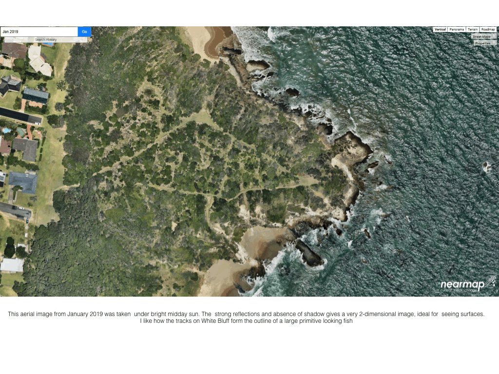
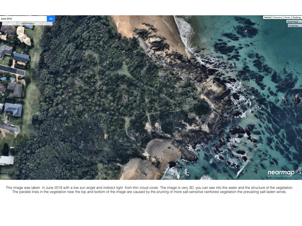
As part of his research for any ecology job, Greg reviews aerial imagery, maps, legislation and policies for information about the history of a site such as changes to vegetation and any legal requirements that may apply. He has done similar research for White Bluff and has shared it with the project to help inspire the art works that are currently taking shape.
Greg has also been integral in providing the project participants with an understanding of the amazing geology of the White Bluff site.
He presented a simplified explanation of the geological evolution of White Bluff, synthesised from a wide range of online material. Greg admits that much of that material is conjectural and may change with further geological research but it gives a great insight into the incredible age and origins of our little bluff.
During the Carboniferous period (360-300 million years ago) most of the world’s coal deposits were laid down. During this time, atmospheric carbon dioxide dropped from approximately 2000ppm (parts per million) to about 300ppm and oxygen levels increased from 15% to 35%. This dramatic change heralded the age of giant insects and the origin of the sediments that became the rocks of White Bluff.
Around that time ‘Australia’ consisted of the West Australian craton, a large old and stable part of the earth’s crust that had survived for at least 2,000 million years. It was attached to Antarctica which, together with parts of South America, Africa, Arabia and India formed the supercontinent Gondwana.
During this period, the ocean floor was being pushed westward under the eastern margin of Gondwana’s continental crust, a process known as subduction. The subduction consisted of (west to east) a magmatic arc (a chain of volcanoes formed from the melting of the subducting oceanic plate), a forearc basin (a deep offshore trench where the ocean floor dips below the continental crust) and an accretionary wedge (a mass of sedimentary material scraped off an oceanic crust during subduction and piled up at the edge of the continental crust). And when you hear Greg explain this, it is amazing how vibrant this ancient geological process becomes. Can you feel all that rock moving and shifting and scarping and pushing. The New England Orogen (a belt of the earth's crust involved in the formation of mountains), which includes the Coffs Harbour Block, was one of many large blocks of disparate materials attached to the eastern side of the craton during this period.
Then, in the Late Carboniferous (330-300 mya) Euramerica collided with Gondwana to form Pangaea. The collision closed the Rheic Ocean and affected ocean circulation, initiating the great Carboniferous Ice Age.
During that ice age the Earth repeatedly cooled then warmed and great sheets of glacial ice accumulated, pulverizing the volcanoes of the magmatic arc, then melting, then reaccumulating in cycles. Floods associated with each melting deposited huge unstable wedges of volcanic sediment along the trench margin. These were periodically redistributed by underwater landslides or ‘turbidity- currents’ triggered by earthquakes. Each turbidity current sorted the sediments by grain size, with larger grains settling first close to shore, and small grains settling later and further away. These sediment layers were gradually metamorphosed by heat and the pressure from the weight of overlying sediments to form the parent rocks of the Coffs Harbour Block.
Next, early in the Permian Period (300-250mya), there was a transition from subduction to strike-slip faults along eastern Australia (strike-slip faults are vertical fractures where adjoining blocks move horizontally past each other). The Texas, Coffs Harbour and Nambucca oroclines (megafolds) commenced and the beds of the Coffs Harbour block were broken up and imbricated (arranged so that they overlapped like roof tiles)
During the Triassic Period (250-200 mya) subduction and accretion resumed. Intrusion of granitic rocks (such as those of the small headland at the northern end of Emerald Beach) occurred. There was additional minor metamorphism of the Moombil and Brooklana beds which are within the southward moving Coffs Harbour Block. This was associated with the block’s collision with the Nambucca Block along the Gleniffer Fault about 240 mya.
During the Jurassic and Cretaceous Periods (200-70 mya) subduction and accretion continued, at least until 150mya and about 70 mya saw the end of the Gondwana supercontinent, as Australia finally separated from Antarctica.
All these Permian to Cretaceous accretions were rifted off eastern Australia during the breakup of Gondwana to form Zealandia, also known as the New Zealand continent or Tasmantis. Zealandia is an almost entirely submerged mass of continental crust that sank after breaking away from Australia 60–85 million years ago. It includes New Caledonia, Norfolk and Lord Howe Islands and New Zealand. The Coffs Harbour Block and White Bluff/Coffs Harbour Block consists of (from North to South) the Gundahl Complex, Cunglebung Creek beds, Coramba Beds, Brooklana Beds and Moombil Beds. All are metamorphosed and imbricated sedimentary rocks.
White Bluff (and other headlands from Coffs Harbour to Arrawarra) is an outcrop of the Coramba Beds. White Bluff is unusual in that the sediments are very pale in colour, unlike other headlands in the area. Similar pale sediments occur on the southern half of Split Solitary island and also occur on the coast range at the end of Condons Road, west of Hearnes Lake.

White Bluff

Split Solitary Island

White Bluff
The Coramba beds are dominated by thin-bedded and thick-bedded turbidites with horizons containing abundant thick layers of massive to graded sandstone and rarely conglomerate. The depositional environment for the Coramba beds was a trench wedge with the mudstone-rich parts representing deposition in the outer trench wedge and the sandstone units having formed in an axial channel in the inner trench wedge. These trench wedge deposits were added to the subduction complex by frontal accretion. The great thickness of these deposits in the Coramba beds is likely to have resulted from internal imbrication, a process where a series of rock slices overlap, somewhat similar to a set of books leaning against one another on an incompletely filled shelf. Imbrication is widespread in the rocks of the Coffs Harbour Block and accounts for the apparently exaggerated thickness of the Coramba Beds (ca 25km).
The imbrication process partially shuffled the Coramba Beds, with older and younger slices sometimes out of order. It also stood the slices more or less on end, with the sediment layers now more or less vertical.
The orientation of the slices was WNW-ESE, indicating that the force causing the imbrication was from the NNE. Many major ridgelines along the Coffs Coast follow the orientation of these slices, and the pattern of headlands and infilled bays and beaches reflects the more and less erodible vertical sediment layers respectively. These imbricate layers were later faulted, with the somewhat radial pattern of faults occurring more or less at right angles to the imbrication reflecting the rotation associated with the development of the orocline during the Late Carboniferous and Permian Periods.
Now, of course, these geological changes continue. The rising ocean, the earth’s warming temperatures, will wrought new and profound changes. Geology, historically and into the future, outdates us all. And while the immense age of the earth is evident from Greg’s explanation above, many White Bluff artists still talk about the dramatic imagery he provided when explaining these processes during the team’s off-shore tour of the headland. Standing on the jostled deck of the Jetty Dive boat, Greg described the great chunks of earth tipped on their side and slamming into the Australian continent. He connected for us the line of sedimentary rock, that distinctive white colour, which can be seen reaching from White Bluff to Split Solitary Island. He made the team think about what couldn’t be seen, the line of connections beneath the water, the deep age of these connections and our small place within it.